Chinook Pass South Bike Climb - PJAMM Cycling

16.3
PDI
11.2 mi
DISTANCE
3,101 ft
GAINED
5.2 %
AVG. GRADE

FULL CLIMB STATS

Page Contributor(s): Bruce Hamilton/Stacy Topping, USA; Kyle Stanton-Wyman, North Bend, WA

INTRO

Ranked #5 in Washington, this is a wonderfully scenic bike climb in northern Washington, 90 miles southeast of Tacoma and within ten miles of Mt. Rainier at locations along the climb. 

"123/Chinook Pass West is a long and shallow ascent near Mount Rainier. Scenery is the order of the day on this hill as thick northwest woods great riders over its lower half. As you ride the trees pull back a bit and you can catch a glimpse of the big mountain in spots. Toward the top the scenery is alpine along some exposed stretches and a short tunnel. At Cayuse Pass (Route 410) turn right to continue the climb. This section is quite alpine as well and you soon come to the obvious Chinook Pass..." (This quote is presented with the approval of John Summerson, from his book, The Complete Guide to Climbing (by Bike), 2nd Edition, pg. 228.)

PLAN YOUR ROUTE

We've partnered with Sherpa-Map.com to bring you the best route planning tool. With a PRO Membership you can use this climb as a reference when creating your route.
This 12.5 miles climb averages 4.8%.  30% (3.7 miles) is at grade 0-5%, and 67% (8.4 miles) is 5-10%. The steepest quarter-mile is 6.3% and steepest continuous mile is 6.1%. 
Roadway:  Two lane highway in excellent condition with a narrow shoulder most of the climb.

Traffic  Mile to moderate

Parking:  Park on the side of Hwy 123 at the entrance to Grove of the Patriarchs Trail 2 miles from the start of the climb - MapStreet View.
Provisions:  None on the route. 
Before heading out on any cycling adventure check out our Things to Bring on a Cycling Trip and use our interactive check list to ensure you don't forget anything.
This climb is in Mt. Rainier National Park.

This is a remote climb but there are a few options for motel rentals in the area.  There are also houses and cabins for rent in and north of Packwood, WA.

Use the “Routes in Area” button on the menu bar above to see other bike climbs in this area. 

ROUTE MAP

MEMBER RATING

Not Yet Rated
-
Road
-
Traffic
-
Scenery

CURRENT WEATHER

PJAMM TRIPS ADVENTURE STARTER BUNDLES

Check out PJAMM Adventure's prepackaged (self-guided) cycling trips. They will help you plan, document and conquer your next adventure.
ALL TRIPS
Browse all of our prepackaged trips and find your next adventure!
Olympic NP: Hurricane Ridge
United States (WA), Canada
8 ROUTES
19 POIs
ROUTE STATS (TOTAL)
125
mi
DISTANCE
14,009
ft
ELEV. GAIN

NEARBY CLIMBS (0) RADIAL PROXIMITY

FROM
No Climbs Found

MEMBER REVIEWS & COMMENTS

Let us know what you thought of this climb. Signup for our FREE membership to write a review or post a comment.
Already have an account?
ROUTE MAP
PROFILE TOOL
Route Data
S.G. (%)
hide
Segment Data
hide
CLIMB SUMMARY

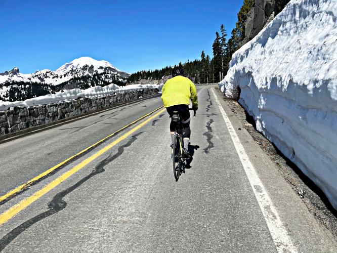
Cycling Chinook Pass, Washington - snow covered Mt. Rainier as seen from the road on Chinook Pass

Cycling Chinook Pass, Washington

Ride 12.5 miles gaining 3,206’ at 4.8% average grade.

This is a wonderfully scenic bike climb in northern Washington, 90 miles southeast of Tacoma and within ten miles of Mt. Rainier at locations along the climb. Mount Rainier is in the Cascade Subrange of the Pacific Coast Mountain Range.

Cycling Chinook Pass, Washington - photo collage, Mt. Rainier from afar with reflection in water, cyclist riding next to road sign for 410 East, person looking over rock formation down on road far below, PJAMM Cycling logo in corner

Begin the climbin the heavily forested Mount Rainier National Park.

Photo left - Chinook Cascades at mile 2.1

Photo right - Deer Creek at the hairpin at mile 3.7

Route 410 traveling through Chinook Pass is also known as the Chinook Scenic Byway, and is considered one of the most beautiful routes in the United States.  The summit of Chinook Pass is above the treeline, so there are many opportunities to stop along the roadway to see incredible scenery.  Chinook Pass also holds the east entrance to Mount Rainier National Park, so this portion of the road is closed to commercial vehicles, making this area even more popular for summer tourists.  The road is typically closed from November to May, due to its high elevation making it at risk for avalanche danger (Chinook Pass).

Turn right (east) onto Hwy 410 to Chinook Pass at mile 7.6

Overlook of 3 giant hairpins (2.1 miles 4.6%) at mile 9.5

Cycling Chinook Pass, Washington - Seattle skyline as seen from Kerry Park in northwest Seattle, Mt. Rainier seen in the distance

Mt. Rainier as seen from northwest Seattle looking southeast.